It was 75 degrees yesterday afternoon where I work near the Gulf Coast. This morning it was 30. That is a drop of 45 degrees over night. Although I work near the coast, my home is located in the beautiful Texas Hill Country. It was 80 degrees there yesterday afternoon and 15 this morning. That is a 65 degree drop over night. Of course, the temperature normally drops from afternoon to morning, but this drop illustrates that, once again, a large mass of Arctic air has descended down the middle of the country.
These figures also illustrate something else. When we get large winter storms like this I frequently here comments along the line of 'so much for global warming.' My first reaction to this is, its winter time, are you really surprised to see a winter storm? But, take a look at those figures. It was 80 degrees the first weekend of March. Where are the comments about that? Its winter time and, no, I don't expect it to be 80 degrees.
Actually, storms like this are, at least partly, due to global warming. The polar cap still has a long, dark winter and the air up there gets cold. Climate change is not going to change that. But, that air has a huge mass. Assuming the cold air mass is a large disk with a radius of 500 miles, it would have a mass of approximately 10 trillion tons. To get that mass moving and bring it down into the middle of the country requires an amount of energy in excess of 10^17 joules of energy (assuming it moves at 30 mph and ignoring friction and turbulence). This is about 1000 times the entire annual energy consumption of the United States. Of course, these are only back of the envelope estimates, but they are going to be pretty accurate and they also make the point.
This energy has to come from somewhere. Global warming will mean that winters will get shorter and milder, but winter storms will become more violent. And, that is just what we have been seeing.
Credit: xkcd
Thinking it through, if the heat has to come from somewhere, then so does the cold air. If cold air is moving out of the Arctic down into the lower latitudes, that means something has to be moving into the Arctic region to take its place. As it turns out, Russia is having a record warm winter. But, so is the Arctic. Look at this weather map for the Arctic region:
Source: NOAA Arctic Theme Page
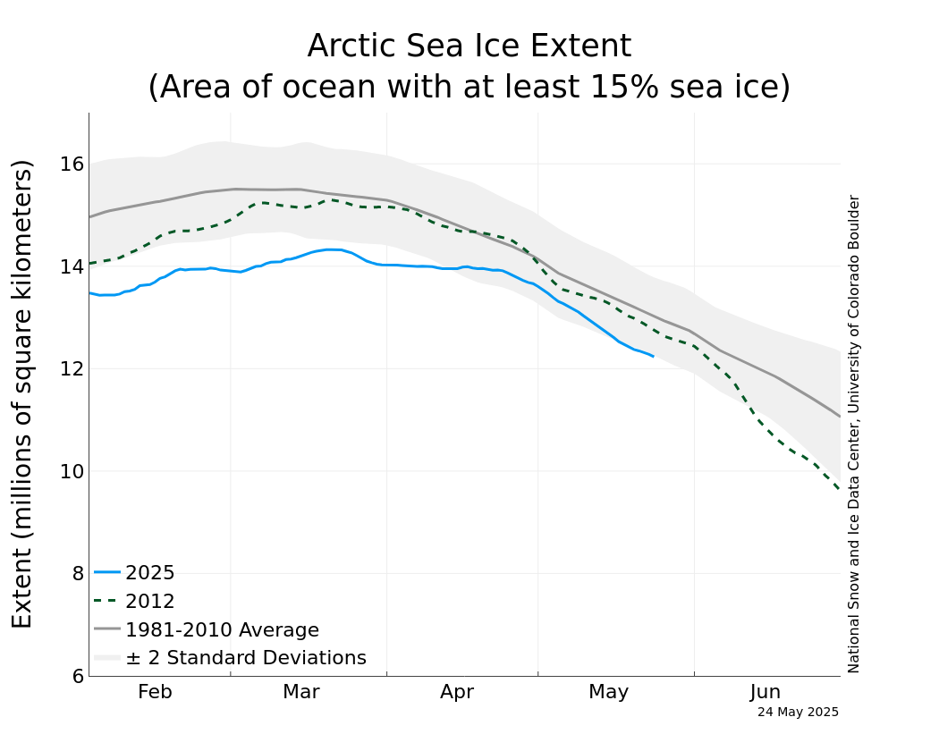
The temperatures there are unbelievably warm. The equinox is approaching in about 2 1/2 weeks, so most of the region is experiencing day time and even the north pole has twilight before it's one and only sunrise of the year. That explains only a small part of the warmth. These temperatures are not characteristic of the region for this time of year. And, this does not bode well for the Arctic sea ice. Check out this graph:

Source: National Snow and Ice Data Center
We can see that the sea ice extent this year is almost two standard deviations below the long-term average. We have not yet reached maximum extent, but it is coming up soon. Unless there is a sudden surge, the Arctic will be starting the summer melt season with a greatly reduced amount of sea ice, and that is not good news.
No comments:
Post a Comment