Naturally, we are concerned with the conditions of the GIS. First, because it is a factor in the world's weather and most North Atlantic icebergs originate here, but because it is a indicator of how the climate is going. Unfortunately, we see one more indicator of global warming going on here.
We would expect to see melting and freezing in the ice sheet due to the seasons, and that is what we see. Some of the ice melts in the summer and then snow is deposited in the winter. In addition to that, we also see that the amount of melt in the summer is greater than the amount of deposit in the winter. Take a look at this graph here:
 |
| Source: Polar Portal |
By the way, this occurred during the period when deniers have insisted there is no global warming. Once again, we see facts put the lie to their claims.
So, how are things going this year? Again, not good. Take a look here:
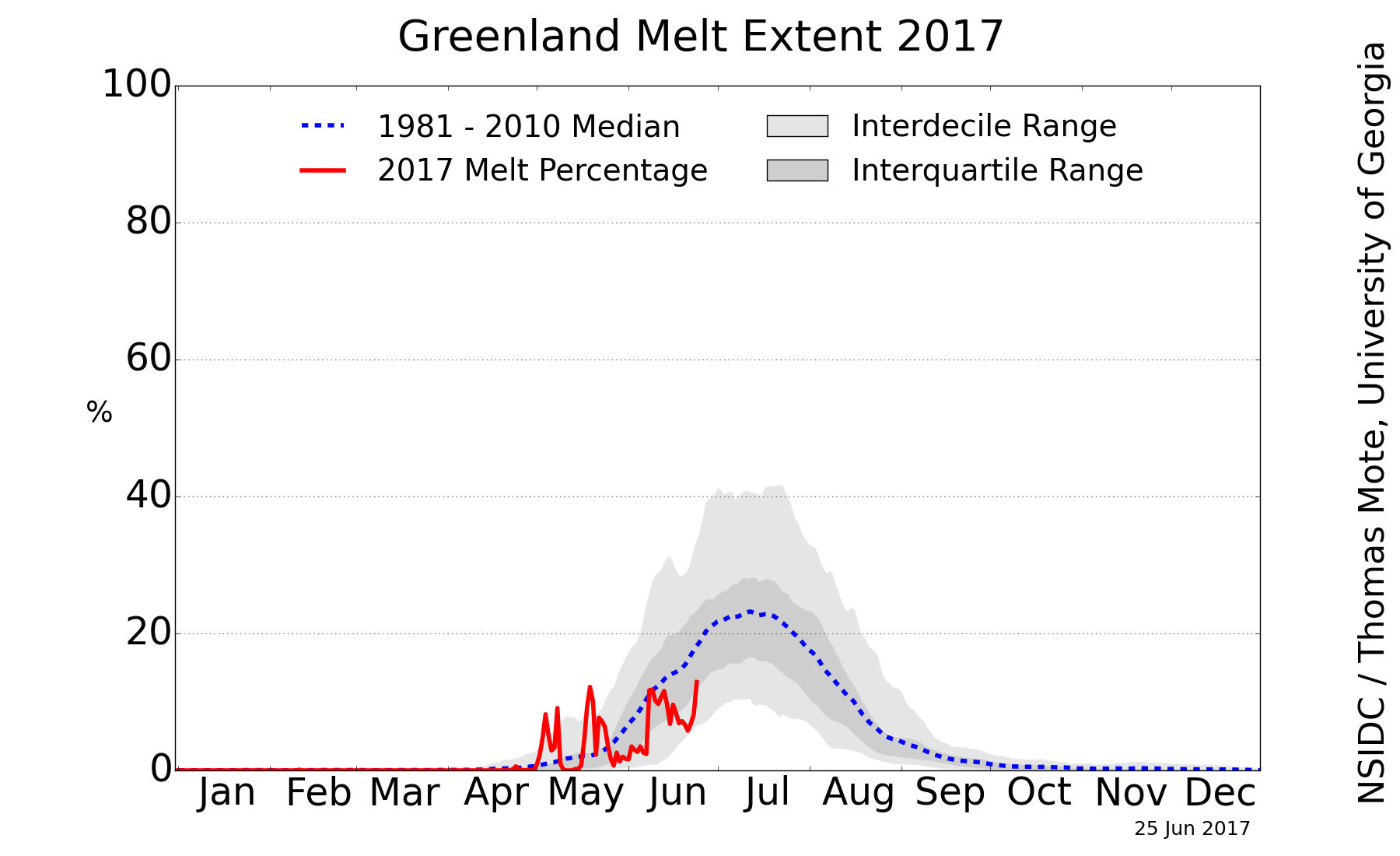 |
| Source: NSIDC |
And the forecast for additional melting? It is difficult to make a good forecast, but there is one thing that troubles me. Look at this plot.
 |
| Source: Polar Portal |
This plot shows the albedo relative to the long-term average. Albedo is the measure of how well something reflects light. Something with an albedo of 1 (or 100) is a perfect reflector. An albedo of 0 means it reflects nothing at all - it would be perfectly black. Red areas on the above plot show where the current albedo is lower than the long-term average. Blue areas show where the current albedo is higher than the long-term average. The lower the albedo, the worse the surface reflects light and the more light it absorbs, leading to increased melting. Blue areas mean the albedo is higher and reflects light better, so melting would be reduced compared to the long-term average. The plot is not encouraging. There are some areas that are colored blue, but some shade of red dominates the plot area.
What could cause the lower albedo? There are two things that have been linked to this. One is soot from fires, the other is melt ponds. As we have more forest and wild fires due to climate change, the soot is carried on the winds and some of it is deposited on the GIS, lowering the albedo. Then, as the ice melts and forms ponds of water, the albedo drops even more because ice is a good reflector, but water is a good absorber.
Combining this data and the melting trend so far makes me think this will be a bad year for ice melt on Greenland. The summer of 2012 was the record bad year, hopefully we won't get that bad.
I would like to see a global picture or the ice mass, because we talk about GLOBAL warming, right? How come you always rant about cherry picking the data but now you only show what happens in Greenland and not the Antarctic? How does the combined Greenland and Antarctic ice mass combine on a graph?
ReplyDeleteThe issue of anything having to do with Antarctica is difficult, one way or the other. This is because Antarctica is isolated from the rest of the world by circumpolar currents in the air and sea, resulting in an environment that is greatly separated from the rest of the world.
DeleteBut, we have been able to measure that the level of sea ice around Antarctica is increasing in recent years. I would like to say this is bad news, but it isn't. As we learn more and more about this situation, the conclusion we keep reaching is that this is not a good thing. See this posting here on Skeptical Science:
http://www.skepticalscience.com/antarctica-gaining-ice.htm
There is also a nice discussion at the National Snow and Ice Data Center:
http://nsidc.org/cryosphere/seaice/characteristics/difference.html
While there are a number of issues involved, the most important one (in my opinion) is that a big reason the sea ice is increasing is because more and more ice is flowing off the continent and into the sea.
So, to give you a direct answer to a direct question - the total amount of land ice on Greenland and Antarctica combined is decreasing. If you were to include the sea ice, the total is also decreasing, but not by as much (some of that lost land ice in Antarctica is being turned into sea ice).
Is there any study to suggest increased wildfires due to global warming?
ReplyDeleteOverall, the evidence is pretty clear that climate change is making wildfires worse.
Deletehttp://www.nwf.org/Wildlife/Threats-to-Wildlife/Global-Warming/Global-Warming-is-Causing-Extreme-Weather/Wildfires.aspx
http://www.ucsusa.org/global_warming/science_and_impacts/impacts/global-warming-and-wildfire.html
http://www.nature.com/news/wildfires-ignite-debate-on-global-warming-1.11025