Let's update the tally for the year:
September was the hottest September ever recorded;
August was the hottest August ever recorded;
July was the fourth hottest July ever recorded;
June 2014 was the hottest June ever recorded;
May was the hottest May ever recorded;
April tied 2010 as the hottest April ever recorded;
March was the fourth hottest March ever recorded;
We got a break in February. It was only the 21st hottest February ever recorded;
But, that break followed the hottest January since 2007 and the fourth hottest January on record.
So, let's see what the score is so far for 2014: one 21st hottest month, three 4th hottest months, and five hottest months ever.
The January through September period was tied with 1998 and 2010 as the hottest such period ever. If 2014 continues the way it has, it will be the hottest year ever recorded.
But, the deniers will continue to claim the warming has stopped. Then, they get upset when anyone calls them a denier. They are called deniers because they are denying the facts.
Here are some of the highlights from the global and national reports:
Global
- The combined average temperature over global land and ocean surfaces for September 2014 was the highest on record for September, at 0.72°C (1.30°F) above the 20th century average of 15.0°C (59.0°F).
- The global land surface temperature was 0.89°C (1.60°F) above the 20th century average of 12.0°C (53.6°F), tying with 2013 as the sixth warmest September on record. For the ocean, the September global sea surface temperature was 0.66°C (1.19°F) above the 20th century average of 16.2°C (61.1°F), the highest on record for September and also the highest on record for any month.
- The combined global land and ocean average surface temperature for the January–September period (year-to-date) was 0.68°C (1.22°F) above the 20th century average of 14.1°C (57.5°F), tying with 1998 and 2010 as the warmest such period on record.
- September temperatures were above average across Australia,
with daily high temperatures responsible for much of the warmth. The
September average maximum temperature for the country was 2.03°C (3.7°F)
higher than the 1961–1990 average, the fifth highest maximum
temperature for the month since national records began in 1910. The
state of Western Australia was record warm, at 2.75°C (4.95°F) above
average, breaking the previous record set in 1980 by 0.44°C (0.79°F).
Tasmania reported its second highest September maximum temperature on
record and Victoria reported its seventh highest.
- With high pressure dominating the region for most of the month, the United Kingdom
had its fourth warmest September since national records began in 1910,
with a temperature 1.2°C (2.2°F) higher than the 1981–2010 average.
- France
observed one of its warmest Septembers since national records began in
1900, with a monthly temperature 1.6°C (2.9°F) above the 1981–2010
average. In the southwest, Brittany and Normandy reported monthly
temperatures 2–4°C (4–7°F) higher than average.
- Denmark
had its seventh warmest September since records began in 1874, with a
temperature 1.9°C (3.4°F) higher than the 1961–1990 average and 0.8°C
(1.4°F) higher than the most recent 2001–2010 decadal average . The
average daily maximum temperature was the fifth highest on record for
September while the average daily minimum temperature tied with 1998 as
third highest (maximum and minimum temperature records date to 1953).
- Germany
had a September temperature 1.4°C (2.5°F) higher than the 1981–2010
average. The warmth was widespread across the country, with every state
reporting a higher-than-average September temperature.
- Austria was 0.7°C (1.4°F) higher than its 1981–2010 average. Switzerland had a September temperature 1.0°C (1.8°F) higher than its 1981–2010 average.
"The first nine months of 2014 (January–September) tied with 1998 as the warmest such period on record, with a combined global land and ocean average surface temperature 0.68°C (1.22°F) above the 20th century average of 14.1°C (57.5°F). If 2014 maintains this temperature departure from average for the remainder of the year, it will be the warmest calendar year on record. The past 12 months—October 2013–September 2014—was the warmest 12-month period among all months since records began in 1880, at 0.69°C (1.24°F) above the 20th century average. This breaks the previous record of +0.68°C (+1.22°F) set for the periods September 1998–August 1998, August 2009–July 2010; and September 2013–August 2014."
National
- The September national temperature was 66.2°F, 1.3°F above average. This ranked as the 26th warmest September in the 120-year period of record. The average maximum (daytime) September temperature for the contiguous U.S. was 78.3°F, 0.5°F above the 20th century average, ranking near the median value in the 120-year period of record. The average minimum (nighttime) September temperature was 54.1°F, 2.2°F above the 20th century average, the eighth warmest on record.
- Locations from the Rockies westward were warmer than average during September. California, Nevada, and Utah each had one of the 10 warmest Septembers on record. Much of the East Coast was also warmer than average. Near- to below-average temperatures were observed across much of the Plains and the Midwest. Crops continued to mature at a slower than average rate throughout the Northern Plains and Corn Belt. Early freeze conditions across parts of the Northern Plains ended the growing season earlier than average.
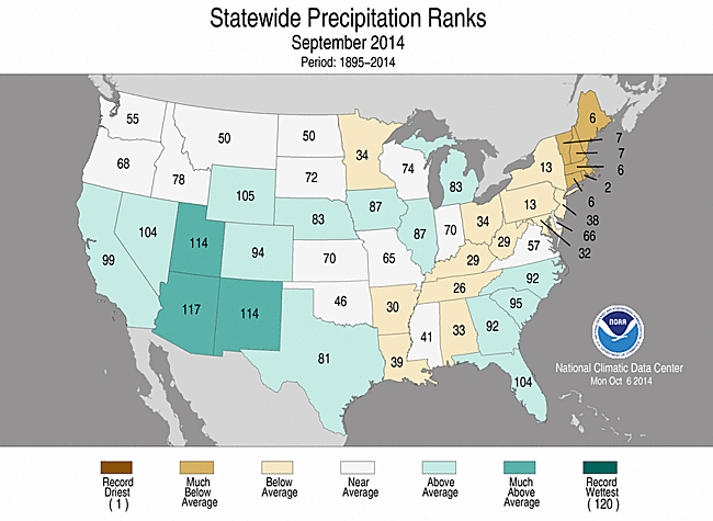
- The September precipitation total for the contiguous U.S. was 2.58 inches, 0.09 inch above average — ranking near the median value in the 120-year period of record.
- The near-average September precipitation total for the contiguous U.S. masked regional extremes. The Southwest was much wetter than average, where enhanced monsoonal flow and the remnants of Hurricanes Norbert and Odile brought an abundance of moisture to the region. Arizona, New Mexico, and Utah each had a top 10 wet September. Parts of the Northern Plains were also wetter than average, where heavy rain caused flooding and record monthly precipitation at a few locations in western South Dakota and Nebraska.
- Much of the Mid-Atlantic and Northeast were drier than average, where Connecticut, Maine, Massachusetts, New Hampshire, Rhode Island, and Vermont each had one of the 10 driest Septembers on record.
- On September 7th and 8th, a plume of moisture associated with the remnants of Hurricane Norbert brought heavy rain to the Desert Southwest. Locations around Phoenix, Arizona received over six inches of precipitation. The Phoenix Sky Harbor airport received 3.30 inches of rain in a seven-hour period on the 8th breaking the record for the rainiest calendar day in Phoenix since records began in 1895. The deluge caused massive flash flooding and the high water forced the closure U.S. Highway 60 and Interstate 10 in Phoenix.
- On September 10th and 11th, an early season snow storm and blast of cold air brought snow to parts of the Northern Rockies and Plains. Several locations in the Black Hills of South Dakota set new records for earliest date of snowfall greater than 1.0 inch including Mount Rushmore which received 8.1 inches of snow and Rapid City which received 1.6 inches.
- According to the September 30th U.S. Drought Monitor report, 30.6 percent of the contiguous U.S. was in drought, down from 32.8 percent at the beginning of the month. Drought conditions improved across the Southwest, Great Basin, Central Plains, and southern Georgia, while conditions worsened in parts of the Southern Plains, Southeast, and the Northeast. Abnormally dry conditions developed in the Mid-Atlantic region. Drought continued to impact California and Nevada, with nearly 100 percent of both states in moderate-to-exceptional drought.
- Alaska was warmer and slightly wetter than average during September. The state had its 11th warmest September in its 1918-2014 record, with a temperature 2.5°F above the 1971-2000 average. Locations in western Alaska were notably warm; Cold Bay had its warmest September on record. Alaska's September precipitation total was 9.0 percent above the 1971-2000 average.
- The end of September was notably warm for Hawaii, with several daily and monthly temperature records broken. On September 26th, the temperature at Hilo reached 93°F, besting the previous warmest September temperature record for the city set on September 21, 1951. This was also 1°F shy of the all-time warmest temperature on record at Hilo, which occurred in November 2013.
- On the daily scale during September, there were 4,285 record warm daily high (1,091) and low (3,194) temperature records and 2,869 record cold daily high (2,122) and low (747) temperature records.

September 2014 Statewide Temperature ranks
September 2014 Statewide Precipitation ranks
No comments:
Post a Comment